GPS-RTK network geodetic monitoring
Principle of the method applied to ground movement monitoring
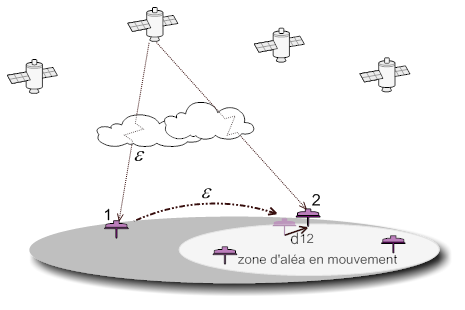
The principle of the method is based on a distance calculation between a measurement point (GPS antenna) and several other points (satellites). This calculation is done by evaluating the travel time of a calibrated signal emitted by the satellites.
There are several calculation methods, offering different performances. For tracking ground movements, with movements of sub-millimimeter to metric per hour, the RTK method, based on the comparison of signal phases is preferred because it allows for measurements both accurate and fast.
Differential measurement further improves the measurement accuracy. It requires the use of a so-called reference GPS station placed in a near stable zone: all the position variations recorded by this station are considered as measurement errors (mainly due to the crossing of the atmosphere by the signal or the earth tide). These variations are then applied to the measurement stations in the hazard area, affected by the same measurement errors. These corrections are relevant when the reference station is close to the measurement stations.
Real-time RTK differential GPS monitoring
When corrections are taken into account in real time, we speak of RTK geodetic monitoring (real time kinematic) accurate real-time differential GPS measurement. The corrections are communicated by radio link, by the reference station, to one or more measurement stations in the hazard area
The method provides all the quantitative data necessary for the complete analysis of the field of displacement, while retaining as much as possible the "real time" aspect in the context of an operational field movement monitoring.
It is then possible to obtain a precision of at least centimeter (differential) even with short measurement cycles (typically from 5 minutes to 30 minutes) and without a posteriori treatment, which allows to exploit it in near real time for the management of ground movements hazard.
Lastly, the quality of the data can be evaluated on the basis of quantitative indicators such as:
the number of satellites: from 7 satellites, the measurement is of quality;
the DOP (Dilution of Precision) factor: it characterizes the quality of the satellite constellation, both from the point of view of the number of satellites but also from their geometric distribution. A DOP less than 1 is considered excellent;
the number of measurements and corrections: when the number of corrections is very close to the number of measurements, there is good communication between the reference beacon and the measurement beacons.
The measurement variations of the reference station, in a stable zone, are transmitted in the form of corrections to the measurement stations, in the movement zone.
The conditions for deploying GPS stations
Since the measure is strictly local, it is important to implement the stations at the key points of the site. The reference station must be installed in an area deemed to be stable, as close as possible from the measurement stations so that the corrections are as fair as possible.
An inherent requirement of the measurement is also to have a clear environment to ensure a good satellite coverage and a good radio link between the different measurement stations and reference station to limit the multiple paths and the effects of masks.
Lastly, the measurement rate must be adapted to the site conditions and to the power supply modes of the measuring equipment (on a permanent electrical network or on a battery with or without with solar panel charging).
Useful links:
Technical sheet: SYGTEO RPGS
Observation and multi-parameter monitoring (In addition to the differential GPS monitoring system, it may be useful to deploy additional measurement equipment).