RFCS RAFF Project
Long-Range Laser Scan Campaign at Lake Most (Czech Republic)
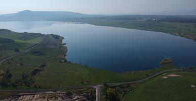
In September 2019, Ineris carried out a 3D LiDar survey near the artificial lake of Most (Czech Republic), at a depth of 75 meters, created by the flooding of an old open-cast lignite mine.
vincent.renaud@ineris.fr-
This measurement campaign is part of the European project RAFF (Risk assessment of final pits during flooding) started in 2019 for a period of 3 years, whose objective is to assess the risk of instability of flooded mining reservoirs establish a methodology for their long-term monitoring.
The data thus acquired will be combined with a sonar survey to accurately reconstruct the complete geometry of the reservoir and its banks. They will then be used by Ineris and its partners to develop 3D numerical models to understand the influence of the properties of geomaterials and geology on the stability of reservoir slopes in the short and long term.
By contributing to this project, Ineris shares all of its expertise and know-how, based on a long experience feedback, in the management of the long-term residual risks of the post-mining and extractive industries. benefit from other partner organizations.
More about the RFCS RAFF project: News: RFCS RAFF project - long-range laser scanning campaign at Lake Most.