cenaris.multiparametres.title
To measure with the best resolution possible relevant variables with various natures
Observations and monitoring of gravitational instabilities such as cavern collapses, ground deformation, rock landslides or slope landslides often involve synchronously collecting physical parameters to learn about the evolution of the site, as well as the engines of instability and evolution.
Many types of measurement data can now be considered: geotechnical, hydrological, geodetic, meteorological, seismic and microseismic.
To characterize the hazard, detect and anticipate its occurrence
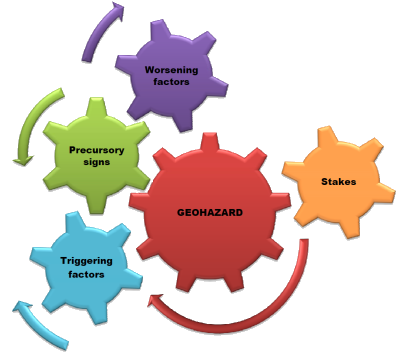
These data can be combined to establish probabilistic laws of occurrence of the hazard or to create conditions conducive to reliable detection of risk situations.The monitoring of possible triggering factors, for example an exceptional rainfall, an increase in the pore pressure in the ground, a strong seismic event, or precursory signs such as intense microseismic activity or the appearance of large deformations is in some cases fundamental.
For a global supervision of risks
It covers hazards, and, if necessary, the most vulnerable material stakes which are bound to it. Stakes supervision – buildings, works, infrastructures, etc. – when possible, can considerably improve the evaluation and the management of a crisis and post-crisis situation.
The precise choice of instruments, their number, their positioning, etc. is to be defined according to the conditions of each site, including in terms of stakes, environmental technical constraints and available financial means.
Link :
Fiche technique : SYTGEM geotechnical and microseismic monitoring system